Sponsor Any Post or Page on the Site. Just Contact Me to Discuss.
This is archived content that used to be on the Met Office website, but isn’t anymore so I decided to resurrect it for posterity, adding my own comments and adaptions. It’s a page to refer to when people talk about the harsh winters of 1946-47 and 1962-63, the two UK winters that are used as benchmarks for how bad winter can get.
Rarely in the UK – or anywhere, for that matter – is a train completely buried in snow. But that’s exactly what happened on Dartmoor in March 1891 and in northern Scotland in January 1978. The winters that produced such phenomenal snowstorms were not, however, generally snowy – unlike the remarkable winter of 1947, the snowiest since 1814.

Fig 1: A car stuck in snow at Hebden Bridge – 1963
Severe winters
Since daily meteorological records began in Britain in the 17th century, there have been a number of severe winters. The coldest of all was probably 1684, when the diarist John Evelyn took a coach to Lambeth along the frozen River Thames. Frost Fairs were frequent as the flow of the Thames was restricted by the bridges, slowing it down and making it more susceptible to freezing over.
There was an exceptionally cold and protracted winter in 1739/40 when, between November 1739 and May 1740, snow fell on 39 days in the London area. January in both 1795 and 1814 were colder than January 1740, and the month of February in 1855, 1895 and 1947 were colder than February 1740.
England and Wales would have to wait 223 years for a winter as cold as 1740: this came in 1963.
But what was so remarkable about the 1739/40 winter however, is that the mean temperatures of both January and February were below freezing (0 °C) in the Midlands and southern England. The only other known instance of two successive months with mean temperatures below freezing took place in December 1878 and January 1879.
Before the brutal winter of 1962-63, there was also the equally notorious winter of 1946-47.
The serious snowfall in 1947
Although there were many shorter wintry interludes before Christmas in the winter of 1946-47, the ‘famous’ part of the winter didn’t really get going until the last third of January (see below).
From 22th January to 17th March in 1947, snow fell every day somewhere in the UK, with the weather so cold that the snow accumulated to a great depth. The temperature seldom rose more than a degree or two above freezing, which meant that very little melt occurred and snow just piled up, layer upon layer, until great drifts were everywhere.
There were several snowfalls of 60cm (2 ft) or more, and depths of level snow reached 150 cm (6 ft) in upper Teesdale and the Denbighshire Hills. Across Britain, drifts more than five metres (16 ft) deep blocked roads and railways. People were cut off for days. The armed services dropped supplies by helicopter to isolated farmsteads and villages, and helped to clear roads and railways.
The Calm Before the Storm
In mid January 1947, no-one expected the winter to go down in the annals as the snowiest since 1814 and among the coldest on record. After two cold spells that had failed to last – one before Christmas 1946, the other during the first week of January – the weather had turned unseasonably mild.
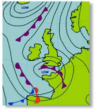
Fig 2: 0600 UTC on 31 January 1947. A low near the channel islands and high over southern Scandinavia, a typical pressure situation during the 1947 winter. Occlusion giving snow over southern counties of England.
During the night of 15-16th January, the temperature at Leeming in North Yorkshire didn’t fall below 11.7 °C. The following day, maximum temperatures close to 14 °C were recorded in Norfolk, Herefordshire and Flintshire. All this mildness was soon to change.
An area of high pressure moved northwards from France on 18th January. Two days later, the anticyclone was centred off north-west Norway. It then drifted south-east to southern Scandinavia, and dominated the weather over the British Isles for the rest of the month. The first night frost came on the 20th and the winter began in earnest on the 23rd, when snow fell heavily over the south and south-west of England. Even in the Isles of Scilly, a few centimetres of snow fell. The blizzard in south-west England was the worst since 1891; many villages in Devon were isolated.
1947’s Unrelenting harsh weather
- The cold, snowy weather continued through February and into March. Any breaks in the cold weather were short-lived.
- On no day in February 1947 did the temperature at Kew Observatory top 4.4 °C, and only twice in the month was the night minimum temperature above 0 °C
- The mean maximum temperature for the month was 0.5 °C (6.9 °C below average) and the mean minimum was -2.7 °C (4.6 °C below average)
- On 26 of the month’s 28 days, snow was lying at 0900 UTC
- South of a line from The Wash to the River Dee, mean maximum temperatures were everywhere more than 5.5 °C below average and, in some places, more than 7 °C below average
- Mean minimum temperatures were more than 4 °C below average everywhere in the south and south-west of England, and almost 6 °C below average in some places
February 1947 was the coldest February on record in many places and, for its combination of low temperatures with heavy snow, bore comparison with January 1814.
One notable feature of February 1947 was the lack of precipitation in parts of western Scotland. Because of the persistent anticyclonic conditions, some places that were normally very wet had no rain at all. A completely dry month in western Scotland is unusual. It was unprecedented in February.
Another unusual feature of February 1947 was the lack of sunshine in the Midlands and south of England – a complete contrast to the north-west of Scotland, where the weather was unusually sunny.
At Kew, Nottingham and Edgbaston, there was no sun on 22 of the month’s 28 days. At Kew, there was none at all from the 2nd to the 22nd. Hardly anywhere in the Midlands and southern England did the sunshine totals for the month exceed 40 per cent of the long term average.
When skies did clear, night-time temperatures plunged. A minimum of -21 °C was recorded at Woburn in Bedfordshire early on 25 February. Without the cloud, the month would almost certainly have been even colder than it was, certainly at night.
March 1947 : More snow, flooding and then gales
In some parts of the British Isles, snow fell on as many as 26 days in February 1947. Much of the snow was powdery and was soon whipped into deep drifts by the strong winds.
If February hadn’t been enough, March was even worse. In the first half of the month, there were more gales and heavy snowstorms.

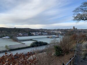
Fig 3: The flooding of 1947
On 4th and 5th March, heavy snow fell over most of England and Wales, with severe drifting. On 6th March, drifts were five metres (16 ft) deep in the Pennines and three metres (10 ft) deep in the Chilterns. In some places, glazed frost occurred. On 10th and 11th March, southern Scotland had its heaviest snowfall of the winter, and the snowstorm reached the Scottish Highlands, where, on 12th March, drifts more than seven metres (23 ft) deep were reported.
Meanwhile, mild air with a temperature of 7-10 °C edged into the extreme south-west of the British Isles on 10th March, bringing rain. The ensuing thaw was rapid. By the evening of 11th March, vast areas of southern England were under water. After weeks of frost, the ground was frozen hard. The rain and meltwater couldn’t soak into the ground. Surface run-off was the only option.
The warm air spread northwards and eastwards. Meltwater from the Welsh mountains poured into the valleys of the Severn and Wye, flooding Herefordshire and Gloucestershire. The rivers of the English Midlands burst their banks. By 13th March, Fenland rivers were close to overspilling.
On 15th March, a deepening depression from the Atlantic approached the British Isles, bringing rain and severe gales. During the afternoon of 16th March, mean winds over southern England reached 50 knots, with gusts of 80-90 knots.
Buildings were damaged and waves were whipped up on floodwaters. In East Anglia, where the major rivers flow north-eastwards, the south-westerly wind drove water before it and waves pounded the dykes. Water levels rose and the dykes gave way. Most of the Fenland was inundated. Troops were called in, but they could do little to stop water pouring through the breached dykes.
River levels rose relentlessly. For example, the banks of the Trent burst at Nottingham on 18th March and hundreds of homes were flooded, many to first floor level. When floodwater reached the tidal part of the Trent, it was impeded by a high spring tide, and the whole of the lower Trent valley was flooded.
The floods in the West Country subsided after 20th March, but rivers continued to rise in eastern England. The Wharfe, Derwent, Aire and Ouse all burst their banks and flooded a huge area of southern Yorkshire. The town of Selby was almost completely under water. Only the ancient abbey and a few streets around the market place escaped inundation. Seventy per cent of all houses in the town were flooded.
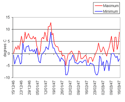
Fig 4: Maximum and minimum temperatures
Edgbaston, Warwickshire 15 Dec 1946-16 Mar 1947
The cold and snowy weather had, at last, ended, but the misery of the floods continued into the spring. And to make matters worse, the severe difficulties caused by the winter of 1947 were aggravated by the fuel and food shortages that remained after the Second World War.

1962-63 was the coldest winter since 1740
The winter of 1962/63 was the coldest over England and Wales since 1740. As in 1947, anticyclones to the north and east of the British Isles brought bitterly cold winds from the east day after day. As in 1947, depressions followed tracks to southward of the British Isles and their fronts brought snow to England, Wales and the southernmost parts of Scotland.
Mean maximum temperatures for January 1963 were more than 5 °C below average over most of Wales, the Midlands and southern England and in some places more than 7 °C below average. Mean minimum temperatures over this area were equally far below average. The story was much the same in February.
The winter began abruptly, just before Christmas in December 1962. The weather in the first three weeks of December was changeable and sometimes stormy, but not particularly snowy. From the 4th to the 6th December, London experienced its worst spell of fog since the Great Smog of 1952.
Ten days later, the weather was particularly wet and stormy, with a gust of 88 knots recorded at Blackpool during the night of 15/16th December, the strongest since records began there in 1946. The weather situation changed markedly on 22nd December. On the 23rd, high pressure extended all the way from the southern Baltic to Cornwall, bringing cold easterly winds to much of England and Wales.
A belt of rain over northern Scotland on Christmas Eve turned to snow as it moved south, giving Glasgow its first white Christmas since 1938. The snow belt reached southern England on Boxing Day and became almost stationary. The following day, snow lay five centimetres deep in the Channel Islands and 30 cm (1 ft) deep in much of southern England.
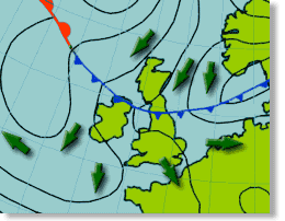
Fig 5: The start of the winter: the cold front that brought the snow to England on 26 December 1962. Chart for 0600 UTC on 26 December.
A blizzard over south-west England and south Wales on 29th and 30th December brought snowdrifts 6m (20 ft) deep. Villages were cut off, some for several days. Roads and railways were blocked. Telephone wires were brought down. Stocks of food ran low. Farmers couldn’t reach their livestock. Thousands of sheep, ponies and cattle starved to death in the fields.
From Boxing Day 1962 to early March 1963, much of England was continuously under snow. Unlike the winter of 1947, however, 1962/63 was sunnier than average in most parts of the area affected, considerably so in some places.
Manchester’s sunshine total for January was more than twice the average. Even in the south of England, where snow fell frequently, sunshine totals were above average in most places.
The most remarkable feature of the 1962/63 winter was not so much its snowiness as its coldness. The winter of 1947 was snowier than 1962/63, but not as cold.
In January 1963, there were 25 or more air frosts almost everywhere in southern England and south Wales. In February 1963, air frost occurred every night at Durham, and almost every night in the English Midlands. At several stations in southern England and south Wales, mean maximum temperatures were below 0 °C in January and little higher in February. Mean minimum temperatures were well below freezing almost everywhere in England, Wales and Scotland away from coasts. Extremely low temperatures were recorded – for example, a minimum of -22.2 °C was recorded at Braemar on 18th January.
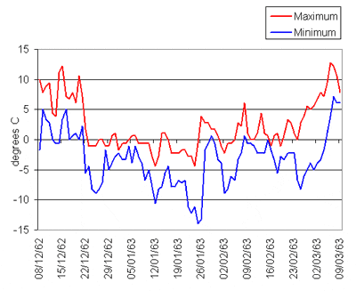
Fig 6: Maximum and minimum temperatures
Leckford, Hampshire 8 Dec 1962 – 9 Mar 1963
Lakes and rivers froze. Ice formed on harbours in the south and east of England. Patches of ice formed on the sea. Huge blocks of ice formed on beaches where waves broke and the spray froze. Coastal marine life suffered severely.
As in 1947, so it was in the winter of 1962/63: brief thaws occurred from time to time, and winter didn’t fully relax its grip before early March. In the last few days of February and the first few days of March 1963, sunny weather brought afternoon temperatures of 4 or 5 °C, but clear skies allowed temperatures to plummet at night. Frosts were moderate or severe.
At last, on 4th March, a mild south-westerly flow of air reached the British Isles. There was occasional rain that day in most parts of Britain, and further rain the following day in the west and north, this time prolonged. On 6th March, there was no frost anywhere in the British Isles and the temperature in London reached 17 °C – the highest since 25th October 1962.
The coldest winter over England and Wales since 1740, and the coldest over Scotland since 1879, had ended. With the thaw came flooding, but nothing like the scale of the 1947 floods. Soon after the winter of 1962/63, life returned to normal.

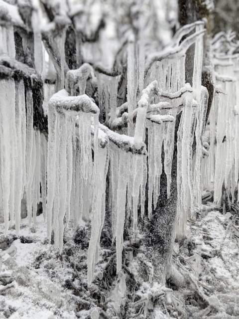
Fig 7: Coastal areas were affected by ice
Photo © Lynn Tait Gallery

Latest Ice and Snow Posts
- June 1975 – Snow stops play in the Cricket
 Sponsor Any Post or Page on the Site. Just Contact Me to Discuss. June 1975 in Durham was one for the books. If you were living in or around County …
 - December 2023 Weather at Durham – Overall very mild
 Sponsor Any Post or Page on the Site. Just Contact Me to Discuss. December 2023. Overall very mild. The cold spell in November 2023 persisted into the first week. The …
 - Tales of The Riverbank in Durham (and more)
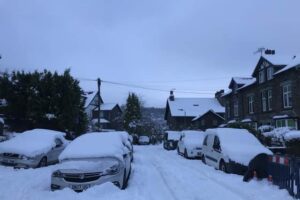
 Sponsor Any Post or Page on the Site. Just Contact Me to Discuss. We managed to haul ourselves out of the house today – 12th December 2022. It was pretty …
 - September 1919 – Heatwave then snow
 Sponsor Any Post or Page on the Site. Just Contact Me to Discuss. Just after the end of WW1, September 1919 was an unusual month as it went from a …
 - February 2021 Weather in Durham – Huge Contrasts
 Sponsor Any Post or Page on the Site. Just Contact Me to Discuss. February 2021 was a month of great contrasts. The second half of January 2021 in Durham was …
 - Some Incredible Ice Formations on Potters Bank, Durham February 2021
 Sponsor Any Post or Page on the Site. Just Contact Me to Discuss. I spotted these photos on Facebook and contacted the owner Zanna Clay, who kindly gave me permission …
Hi Margaret, do you mean December 1946 or 1947?
If you mean 1946, before the Great Winter really got going, well looking at that chart for Edgbaston on this post it looks unremarkable really. Temps were Max 9 Min 1 from the graph. There was low pressure over Scotland, with a brisk Westerly flow on Boxing Day. There were then a couple of mildish days leading up to the New Year.
By the 1st January 1947, low pressure was again prevalent to the North, with Westerlies dominating again.
Does anyone know what the weather was like in the UK December 1947 particularly Boxing Day?