Sponsor Any Post or Page on the Site. Just Contact Me to Discuss.
Severe and Extreme Weather in the North East of England 1901-2010
Another page imported from my Ferryhill Weather website. These are some examples of lesser-known extreme weather that have been experienced in County Durham and the North East area of the UK. Some of them were short lived, and in some cases occurred in isolation against the rest of the seasons. It is anticipated that more will be added after research of the archives.
1901-1910
12-18 December 1901 Snowfall and Flooding
Heavy snow accompanied by a north-easterly gale affected much of Central and Northern England. Drifts of snow to 4 metres depth were recorded in North East England. Severe flooding followed between 15th-18th December 1901.
26-27 February 1903 Severe gale
A severe SW gale (Storm Ulysses) did much damage, especially in Northern England. There was widespread structural damage here , with thousands of tree uprooted and roads blocked.
27-28 December 1906 Snowfall
A severe gale, accompanied by thunderstorms, swept Eastern Scotland and North East England. 35-45cm of snow fell in upland parts of Durham and Northumberland. Max Temp of -2.2 degC on 30th.
21-30 January 1910 Snowfall
Heavy snow with severe drifting affected NE England with level depths widely over 30cm (53cm at Wearhead in the Pennines). Several lives were lost and there were also heavy livestock losses too on farms. Temps down to -12 degC.


1911-1920
23-24 June 1911 Flooding
A 36 hour downpour deposited 110mm of rain in Upper Weardale (56.1mm in Durham). Extensive flooding resulted in Northumberland and Durham. This took place early in one of the best summers that the UK has ever experienced.
10-12 January 1913 Snowfall
Heavy snow, with drifting affected Northern England, seriously disrupting road and rail traffic. Snow depths of 25-35cm were widely observed. This snow occurred when a depression moved across southern England into cold air to the North. The Northern flank received extensive snowfall and Easterly winds.
18 June 1914 Thunderstorm
An extraordinary (although unmeasured) deluge caused floods and landslips in the Ruffside district of North West Durham, near Blanchland, and there were several lightning fatalities. There were reports of a waterspout and tornado. There were also national storms on this day.
Mid-January to Mid February 1917 Cold and Snowy
It was exceptionally cold, with snow laying 30cm or more deep in North East England during this period, with 45cm at Bellingham in Northumberland. -10.6 degC in Durham on Feb 6th 1917.
1921-1930
31 May 1924 Thunderstorms and floods
On the last day of Spring 1924, there were heavy thunderstorms widely; 104mm of rain fell in Sunderland with serious flooding affecting large parts of Wearside and Tyneside. 70.2mm was gathered in Durham, it’s wettest May day on record.
1931-1940
23-26 February 1933 Snowfall
One of the most severe extreme blizzards of the Century. Deep snow with drifting occured. Some places had over 48hrs of continuous snowfall, with an Easterly gale. Drifts were 14ft deep on the North York Moors. 48.3mm of precipitation in Durham.

Deep snow with drifting. Tow Law Feb 1933.
24-26 January 1935 Severe Gale
There were high winds with damaging gusts. A gust of 87mph being measured at South Shields.
19-20 January 1936 Heavy Snow
Widespread heavy snow blocked many roads and railways. Some roads were blocked for up to 10 days. Snow lay 30cm deep at Bellingham in Northumberland.
11-13 March 1937 Heavy Snowfall
March was the coldest month of the 1936-37 winter, some 2 degC colder than February. Over 60cm of snow fell at Barnard Castle in this late snowstorm.
21-22 December 1938 Severe Cold, heavy snowfall
After a very warm autumn, December turned cold and wintry around 17th/18th. On the 21st-22nd, 30-50cm of snow fell widely, with 60cm in the Pennines of West Durham. This was one of the best White Christmases experienced in the North East.
17-23 January 1940 Severe Cold
The month was dominated by winds from the East. The mean for the month at Durham was -1.5C. On 21st January the temperature fell to -16.1C. At Houghall it was -20C that same morning.
1941-1950
5th January 1941 Severe Cold
This was the then English record minimum of −21.1°C at Houghall, near Durham.
18-20 February 1941 Snowfall then flooding
The great North East Snowstorm. Massive snowfall caused most transport routes to be blocked for several days. Six trains (with 1,000+ passengers) were stranded in drifts on the main East coast rail line between Newcastle and Edinburgh. Power and telegraph lines were brought down. 122mm of level snow was recorded at Consett, 107cm at Durham and 76cm at Newcastle. There was 67 hours of continuous snow in Durham City. Houghall recorded -15 degC after the snowfall. Severe flooding then followed the thaw.

22 June 1941 Thunderstorm
113mm of rainfall was registered in a thunderstorm in Newcastle. There was considerable hail damage in the district. June 1941 was otherwise a very dry month.
29-30 January 1945 Snowfall
January 1945 was a very cold month in North East England. The last week of the month was exceptionally so. A blizzard dropped 25-35cm of snow over a large area. Drifts of 6m blocked road and rail networks.
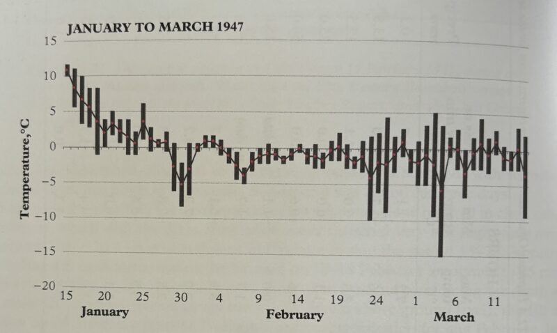
January-March 1947 Snowfall and flooding
Several major snowstorms contributed to considerable snow depths in this very snowy winter. Snow lay 86cm deep at Ushaw near Durham by early March and was measure at 210cm deep at Forrest-in-Teesdale. The temperature dropped to -21.1 degC at Houghall Frost Hollow. By March 12th, warmer moist air brought severe flooding.
8-9 February 1948 Severe gale
Much damage occurred over Northern England in a gale. 95mph recorded at Durham.
31 July 1948 Thunderstorm
Durham had a reported 0.5” of rain in 10 minutes in a thunderstorm on what was the hottest day of the year.
3 September 1948 Gales and Rain
There were gales and rainstorms in Northern England during the night; three quarters of an inch falling in 2 hours on Newcastle, bringing the total in the last 48 hours to 1.57 inches. In south Durham the rain was accompanied by thunder and lightning. The railway track between Spennymoor and Ferryhill was blocked by water covering the track and damaging the embankment. 2.59” of rain recorded at Houghall.
1951-1960
2 June 1953 Unseasonal Snow
On Coronation Day in 1953, snow fell around the Cross Fell area in the North West of the County on what was a pretty bleak day. Maximum temperature in Durham was 7.2 degC.
13 August 1953 Thunderstorms
There was surface water flooding in Newcastle, Durham, Spennymoor, Stanley, Bishop Auckland, Silksworth, and Darlington. Durham (University Observatory) recorded 1.83”; Ushaw College 1.98”.
9-28 February 1955 Heavy snowfalls
There was heavy snow at higher levels, in one of the snowiest periods on record. ‘Operation Snowdrop’ was initiated to drop supplies to upland hill farmers in the North and Scotland. Temps droppped to -12.2 degC in Durham on Feb 20th 1955.

Wagtail Road, Stanley 1955
6-14 March 1958 Heavy Snowfall
There were exceptionally low temperatures recorded during this snowy spell. Minus 8.9 degC on 12th March in Durham. 36cm of snow was reported at Redcar on the North East coast, a very unusual location for such a heavy fall.
1961-1970
16 February 1962 Gales
There were very strong winds associated with a depression that became famous for devastating the City of Sheffield. There was also damage in a broad swathe of North East England.
2 March 1962 Heavy Snow
North East England and the Scottish Borders were hardest hit by heavy snow. 38cm of snow lay at Haydon Bridge.
Heavy snowfall and low temperatures, then flooding.
The first snows began in November 1962, when two shepherds near Rothbury, Northumberland, were lost in a blizzard and were found frozen to death days later. A second covering fell on Christmas Eve. The North East would then stay under an almost continuous blanket of snow until March.
On December 27 1962, a four-hour traffic jam clogged up Newcastle after several lorries got stuck in the snow on Gateshead’s West Street. Many remote farms and villages across Northumberland and Durham were cut off throughout January 1963. Even telegraph poles disappeared beneath massive snowdrifts. All roads to Scotland were impassable. But problems didn’t stop when the ice began to melt, with burst water pipes everywhere.
18 July 1964 Rain and Flooding
‘Washout at Miner’s Gala’. The flooding also created havoc and flooding in other parts of the northeast. Thunderstorms broke over Durham City. ‘Manhole covers are lifting and roads are flooded all over the county’. 33.4mm rain recorded in Durham.
1 March 1965 Heavy Snowfall
Snow fell heavily in North Easterly winds, with depths approaching 20-30cm. 1965 was a very snowy year in the North East. Some very severe frosts recorded, including -12.2 degC in Durham on 2nd March 1965.
29th March 1965 Spring Heat
Shortly after the early cold, the end of March produced a decent hot spell, with temps approaching 25 degC (21.7 degC in Durham). Whitby had it’s warmest day of the entire year.
13 November – 2 December 1965 Heavy Snowfall
Snow fell heavily and frequently in this period, often accompanied by strong winds, leading to extensive drifting. Ushaw, to the West of Durham reported a maximum of 56cm of snow over this period. The 29th November 1965 was the snowiest day, with snow nearly 2ft deep in Durham. Air pressure dropped to 962mb over the North East, indicating the severity of the storm. Around 160mm of precipitation was recorded in Durham in the spell.

14-21 February 1966 Heavy snowfall, thaw and floods
A disruptive snowfall in this period with 30cm at Ushaw. A rapid thaw on 20-21 Feb accompanied by rain led to widespread flooding.
2 July 1968 Thunderstorms
‘Darkness in Newcastle street as torrential rain drives pedestrians into shops’. Motorists were obliged to use headlights. Newcastle Weather Centre reported that extensive thunder clouds covering 10 to 15 mile patches of sky were passing over the city. Newcastle rainfall was 0.75 inch. At Whitley bay the subway on the seafront was at one time under 8 feet of water. Blyth was badly affected, mainly with the loss of telephone services. Teesside was plunged into darkness and shaken by violent thunderstorms. Hailstones up to an inch in diameter hit Stockton and Thornaby. The Fire Brigade reported flooding in a wide area of Durham but especially from the Bishop Auckland area.
Rainfall: Elton 14.0 in 8 mins; West Hartlepool WW 26.7 in 15 mins; Darlington WW 15.2 in 13 mins; Durham 18.3 in 14 mins; Worsall Hall 21.6 in 20 mins; Darlington South Pk 23.1 in 40 mins; Hambleton Lodge Great Smeaton 28 mm in 10 mins.
1971-1980
Early June 1975 Unseasonal Snow
Snow fell down to quite low levels in early June 1975. ‘Snow stopped play’ was a common sight in local cricket matches at the time. Within a few days the temperatures were sweltering in the 80’s in a long hot summer.
1 June 1976 Thunderstorm
Thunderstorm lasting 2 hours in Durham. There was flooding of houses in Ushaw Moor, New Brancepeth, Esh Winning, Brandon and Lanchester. ‘Farmers count the cost after incredible floods hit county’. Worst floods in County Durham for years. Two council houses were flooded on Oakridge Road at Ushaw Moor and became uninhabitable as a result. Farms between Brandon and Bearpark were worst affected. A bullock was washed away by a rising stream and seven acres of kale were lost to water streaming over the land. One small stream rose 10 feet and became 40 feet wide, damaging a bridge. Other farmers suffered similar losses from topsoil being washed away.
11 September 1976 Heavy rain and flooding
This was the wettest day in Durham since records began. 87.8mm of rain was recorded. There had also been 32.3mm the previous day. Severe flooding after the Summer 1976 drought broke, with 121mm of rain in Sedgefield, County Durham and 140mm in other parts of Durham in a North Easterly gale. Floodwaters nearly 2m deep flowed through the village of Stokesley near Middlesbrough.
11-12 January 1978 Severe gale and snowfall
A severe northerly gale brought a storm surge to the East Coast, Then 30-40cm of snow accumulated in parts of NE England. Further south, Margate Pier was destroyed by the storm.
9-13 February 1978 Snowfall
Deep snow disrupted transport and cut power lines in North East England. There was 30cm of snow lying in Durham on 11th February. Snow depths reached 50-80cm in upland parts of Northumberland, and lay 25-30cm deep in Newcastle by the 13th February 1978. Severe frosts from 11th-22nd Feb.
27 December 1978 – 4 January 1979 Rain, flooding and snowfall
Between four and five times the normal monthly rainfall were recorded in NE England this month, 118mm of rain fell at Arkengarthdale, Nth Yorks in 48hrs. The rain then turned to blizzards of snow after Christmas on gale force Easterly winds. Huge drifts built up over New Year. and into early January 1979.

19-23 January 1979 Heavy snowfall
40-50cm of snow accumulated in snowstorms in Januaury 1979.
Mid February 1979
Snow drifted to depths of 6-7 feet along the East Coast in a howling Easterly gale and temperatures were well below freezing on Valentines Day (Max of -1.6 degC on February 14th in Durham).
16-18 March 1979 Snowfall
A storm at the end of winter 1978-79 deposited nearly 30cm of level snow on Durham (much more in drifts in local villages). In Gosforth, just north of Newcastle, the snow depth was nearer 45cm, with Newcastle inaccessible for a time, and many smaller villages were totally isolated, with authorities needing heavy earth-moving equipment to dig them out.

Snowfall in Durham City, March 1979.
2 August 1980 Thunderstorm
A number of houses in Durham and Chester le Street suffered flood damage. Manhole covers were forced off in North Road. One Durham University science laboratory had to be pumped out by the Fire brigade.
1981-1990
December 1981 and January 1982 Snowfall and low temperatures
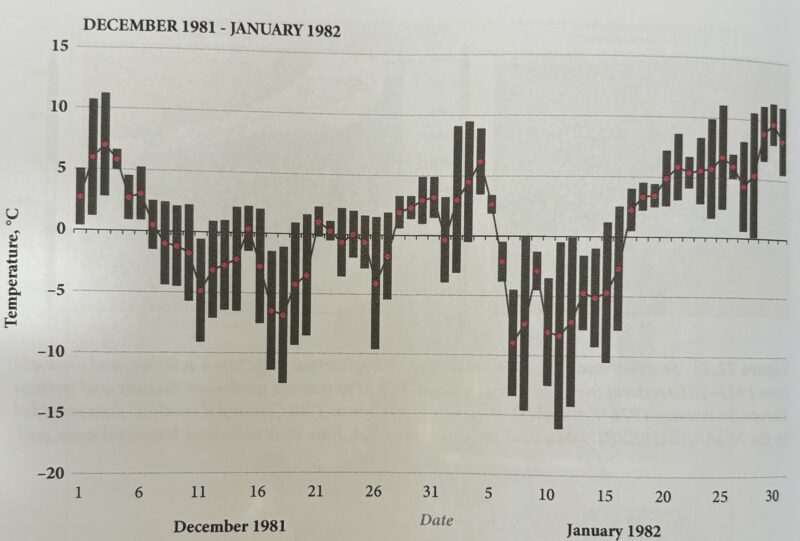
Another cold winter for the North East region came in 1981-82. Temperatures in the region dipped to an average minimum of -3.3 degC. Sections of the rivers Tyne and Wear froze solid – and even some parts of the North Sea north of Berwick froze over for the first time in living memory.
Snow lay on 19 consecutive mornings from 12th – 31st December 1981 in Durham.
Overnight low temperatures broke into the record books when the mercury fell to -21.6 degC in Haydon Bridge. The record for the lowest temperature in England was set in January 1982 in Newport in Shropshire, which hit a bone-chilling -26.1 degC. Temps stayed below freezing from 7th-13th January 1982 in Durham.
Throughout that month, the low temperatures caused havoc as diesel fuel froze in buses, snowploughs, gritters and bin lorries. Eighteen deaths were recorded across Tyneside as a result of hypothermia and exposure to the cold.
31 January – 1 February 1983 Gales
Severe North Westerly gales brought a gust of 93mph at Sunderland.
17 July 1983 Severe flooding
Destructive floods hit the North Pennines following a torrential downpour, and there were reports of peat bogs bursting in West Durham. 104mm of rain was recorded in Ireshopeburn in Upper Teesdale. Exceptional rate-of-rise of the water was the feature of this storm.
26-29 December 1985 Snowfall
25-30cm of snow was recorded in NE England between Christmas and New Year, making it a very festive scene in some places. Little in Durham.
25-26 August 1986 Heavy rain and flooding
The remains of Hurricane Charley caused chaos over the August Bank Holiday in 1986, with more than 100mm of rain falling in parts of Co Durham. There was severe flooding in the Dales, with caravans washed away from some riverside sites.
69.1mm of rain fell in Durham on the 25th August, with 27.7mm on the 26th.
1991-2000
7-9 February 1991 Heavy Snowfall
A phenomenal 46cm of snow fell in Longframlington and at Fylingdales on the North York Moors. The snow was dry and powdery, driven in by a fierce North Easterly wind. This wintry period brought the infamous ‘wrong kind of snow’ comment by a Southern England railway employee.
31 March – 2 April 1992 Severe flooding
Prolonged heavy rain led to widespread flooding on the regions rivers. Urban flooding was extensive on Tyneside, with 110mm of rain falling in Newcastle in a 60 hour period. There was 43mm of rain in Durham on April 1st 1992; the day’s maximum was only 4.8 degC, and snow lay 3cm deep next morning.
13-15 May 1993 Flooding
70-80mm of rain fell in parts of North East England, leading to some flooding.
25-28 January 1996 Heavy snowfall
Heavy and prolonged snow blocked roads in the region towards the end of January 1996. 20-40cm was typical, with 50cm reported from NW County Durham.
4-5 January 1999 Flooding
Serious flooding was reported on the Tyne, Wear and Tees.
3rd-4th June 2000 Very Wet with flooding
A slow moving occluded front produced prolonged rain over North East England. Roads were flooded and houses evacuated in Bishop Auckland (around South Church).
The River Wear burst it’s banks in Durham on 4th June after 54mm of rain fell the previous day, inundating the Maiden Castle Sports Centre.
2001-2010
26 February – 3 March 2001 Heavy snowfall
Deep snow. 33cm measured at Boltshope Park in NW Durham.
8th January 2005 Gales
There was severe weather when a strong gale affecting most of Northern England early in January 2005. Structural damage was widespread, mainly to roofs and trees. An 85mph gust was recorded at Leeming in North Yorkshire.

Gale Damage January 2005
24-25 February 2005 Snowfall
A severe snowstorm lasting 24 hours dumped lots of snow on upland areas in North East England. Snow lay 52cm deep in NW Durham and huge drifts piled up on the North York Moors.

Snow on Blakey Ridge, North Yorks. Feb 25, 2005
15th April 2005 Heavy Rain
39.8mm of cold rain was recorded in Durham. The maximum temperature was 6 degC.
17th July 2009 Flooding
This was an extremely wet day in the North East of England. The rain of 16th-17th July 2009 fell over a very large area and was persistently heavy. 83.2mm fell in Durham on these two days. Many local rivers burst their banks, including the River Wear in Durham and the River Browney at Croxdale. Both were up to 6ft above normal on the morning of 18th July. There were numerous roads blocked around the County by floodwater, and much damage was done.

Durham Flood July 2009
Late November-December 2010 Extreme Cold and Snowfall
The last week of November has seen some of the worst severe weather in November for many a year. Parts of the North East and the East coast of Scotland have seen some significant snowfalls, with depths of over a foot in places. The severe weather continued into December, with record low temperatures across the country. The 2nd December 2010 received 25-30cm of snow, with 40cm further inland. December 2010 was the coldest December since 1895.

28th June 1982 There was snow falling in Newbottle and surrounding area which is not on your list. Why do I remember? it was the week of my wedding and the final touches were beginning. Luckily I had arrived home, (my parents), days earlier. Saturday the 3rd was a sunny day for our day.
Wow, never heard about that one! I’ll go see what the synoptics were like. That’s very late for snow though, are you sure it wasn’t soft hail?
Dave
Hi again. I’ve looked into June 1982 and it was a very wet month overall. It also had some very potent thunderstorms late in the month, and there are comments in weather archives of some places having ‘drifts of hail a foot deep’, so it seems likely that what you observed was hail, not snow.
Durham 28th June 1982 – Max 18.2 degC, Min 10.6 degC, 2.9mm rainfall
Still pretty remarkable though.
Dave